
Running along the eastern border of the Jackson River watershed is the Cowpasture River. This waterway meets the Jackson River below the Town of Iron Gate where the two combine to form the mighty James River. Although only about 12 miles shorter in length than the Jackson, the Cowpasture River still has a drainage area of about 460 square miles. The Cowpasture River has only one large tributary, the Bullpasture River, which drains the northwestern area of the watershed and joins the Cowpasture around Williamsville. Other smaller mountain tributaries that flow into the Cowpasture River include Shaws Fork, Pads Creek, and Simpson Creek, just to name a few. The river begins in Highland County, running through Bath and Alleghany County before meeting the Jackson River in northern Botetourt County.
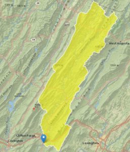
Image 1. The Cowpasture River watershed highlighted in yellow.
Like the name suggests, the Cowpasture River is surrounded primarily by agricultural fields. There is no large urban area in the watershed, but communities like McDowell and Williamsville can be found along the banks of the river. The town of Millboro, which straddles the border between the Cowpasture and Calfpasture watersheds, is home to the Cowpasture River Preservation Association, which is actively involved with stewardship efforts. Read further to find out more about recreation opportunities and water quality challenges on the Cowpasture River.
Water Quality Challenges
The Cowpasture River runs shallow and with the clarity of the water, you will be able to see the river bottom during most, if not all, of your float no matter which section you choose. With no large urban area in the watershed, the river system is not exposed to pollutants associated with large-scale street runoff and urban activities. The banks of the Cowpasture’s lower section are well vegetated and supported by established old growth forests.
As you move up the river, an increasing length of the bank is bordered by agricultural fields. The impact this has on the river is evident, as a majority of the Bullpasture River is considered to be impaired due to bacteria contamination. With no major urban areas, the sources of the bacteria can be narrowed down to livestock and on-site sewer systems. Livestock that have immediate access to the river may directly input nutrients into the water via their waste and allow no chance for nutrients to be assimilated by vegetation or for waste to decompose on land. Fencing off streams from agricultural fields can help reduce the amount of nutrients a river is exposed to and allow the shoreline to be restored to its natural state.
Septic systems that are not properly maintained may also provide a source of nutrients to the stream. When systems are not pumped regularly, they may not function as designed and cause some waste to seep into local waterbodies. It is important to make sure your septic system is functioning properly by having it regularly inspected and pumped at the appropriate intervals. This will not only help with reducing waste flow into waterways, but it will also help prevent the system from failing or backing up into your home.
Recreation on the Cowpasture River
The Cowpasture River offers a wide variety of outdoor recreation activities that allow for people to take on a strenuous hike or spend the day on a relaxing float of the river. The river may not have as much public access as the Jackson River, but the on-the-water opportunities it does have are second to none. The shallow water and short water trails give beginner and novice boaters a chance to become comfortable on the water and build skills needed to tackle their greatest ambitions. The seven miles of floatable water at the mouth of the river also gives you a chance to spend all day on the water if you so desire. This section is a part of the Alleghany Highlands Blueway. To learn more about the blueway here, check out the maps located on the blueway’s website. For anglers, it is an opportunity to work on your skinny water casting and sight fishing skills. With clear water, identifying prime fish habitat might be easier. Structures and water features, like submerged trees or eddies, can be difficult to spot on large and deep rivers. Seeing them in pristine, clear water can help you pick them out more easily when moving on to bigger water. Not to mention the clean water of the river is a good indicator that you will be able to put yourself on a fish.
The Cowpasture River offers a range of species to fish for, including smallmouth bass and rainbow trout. The trout fishing is typically better the further upstream you venture and during the cooler months of the year. Public access to the river becomes more difficult above Williamsville and permission from landowners to fish on the river may be required.
The Wallace Tract is located just below Williamsville off of Indian Draft Road. This area does not provide boat ramps, but there is a trail that runs along the river that gives anglers good access to the shoreline to either fish from the bank or strap on some waders and hop in. This site may be ideal for folks who want to avoid fishing in areas with passing paddlers and enjoy some solitude in a secluded area. The Wallace Tract continues to run along the Cowpasture before veering off and ascending up Shenandoah Mountain. Here, it intersects with a road that will connect you to various trails around the area.
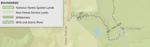
Image 2. The Wallace Tract Site
For people who are looking for a float trip on the river, the Walton Tract is a two mile stretch that has boat landings at the put-in and take-out sites. The float takes you on a long bend at the base of Beards Mountain where you eventually wind your way to a swimming hole and the take-out spot. The float offers a chance to catch smallmouth bass or sunfish, and you can even try your luck with hooking an elusive musky. The Walton Tract area also allows visitors to walk by the river on foot and enjoy areas to view wildlife. A footbridge over the river will takes the trail up Beards Mountain. This trail runs along the Beards Mountain ridge and will even connect you with Douthat State Park.
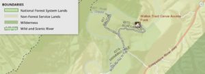
Image 3. The Walton Tract site
The area around and below Interstate 64 is the most accessible stretch of the Cowpasture River. With two public access points, paddlers have the ability to make their float long or short. The Sharon Park and River Access area is 7 miles from the mouth of the Cowpasture River and gives paddlers a chance to maneuver through an extensive stretch of the river. The Cowpasture River is a sinuous river with many bends and meanders, but the beginning section of the Sharon float provides a straight corridor that makes the river seem as if it is a path leading right to the base of the distant mountains. The only obstructions on the river here are bridges for Interstate 64 and Route 269, but they may provide some much-needed shade on a cloudless, sunny day. Paddlers can choose to float almost five miles downstream and exit the river at Evans Tract or continue on towards the James River.
The float furthest downstream will take you on a ride that is over two miles long and brings you to where the James River officially begins. The water trail starts at Evan’s Tract, but you may also find it labeled as the Walter Robinson Canoe Access Point. This last section of the Cowpasture will take you through remote areas that are littered with an array of shale cliffs and shallow riffles. The fishing here provides the best opportunity for smallmouth bass and musky. If you are interested in exploring the trails and floats in the Cowpasture River watershed, check out the U.S. Forest Service’s Interactive Visitor Map.
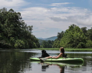
Image 4. A kayaker and their loyal companion admire the distant mountains around the Cowpasture.
It should also be noted that most of the property along the Cowpasture River is privately owned and is not open to the public except at the public access points.
It should also be noted that most of the property along the Cowpasture River is privately owned and is not open to the public except at the public access points.