
Flooding is an issue that seems to have a regular segment on local, state, and national news stations. From King Tides in Norfolk to riverine flooding in Buchanan County, Virginia is not unsusceptible to these events, and the impacts are felt by all parts of the community.
I recently came across a video that shows the sheer ferocity and spontaneity of flooding events. In Queensland, Australia, heavy rainfall devastated multiple cities and towns with water that turned shallow streams into ripping rivers. The most amazing, and terrifying, part of this whole event is the quickness in which streams swelled well beyond their banks and spilled high into the floodplain.
Time-lapse of flooding in Australia
So how does this happen?
Flooding occurs when a large amount of rain falls over a landscape and discharges lots of water in a short period of time. Natural stream systems are designed to mitigate the impacts of heavy rainfall events in a number of ways. Wetlands act as sponges that soak up stormwater and slowly release it into a stream. The sinuosity (how much a stream meanders) of a stream slows the water down and provides more channel to handle larger flows, and floodplains – areas adjacent to streams – allows for stormwater to spill over stream banks to decrease the amount of water that is flowing downstream. All of these mechanisms are important ways a stream system limits the impacts of flooding.
So, if these stream components are effective at mitigating flood events, then why does flooding seem more common and severe?
Part of the problem is attributable to climate change. Climate change will cause changes to local and regional weather patterns that will impact the frequency of high rainfall events. How much a region’s precipitation pattern will change is continuously being studied, and models help show what can be expected for a region. Models show that the Roanoke Valley region can expect to see more rainfall and more severe weather events, which means more flooding.
Climate change is not the only factor. How we manage our landscapes and watersheds – areas that drain to a certain waterbody – has huge implications on flooding size and frequency. In a forested, undisturbed watershed, the landscape is better adapted to handle a heavy rain event. Stormwater is able to infiltrate the ground easily, leading to less runoff that sends rainwater directly to the stream. In the event that flooding occurs, floodwaters are able to spill over into the floodplain to spread out and slow down.
In watersheds with lots of impervious cover, rainwater does not have the chance to infiltrate the soil. Instead, stormwater rushes off hard surfaces and into the stormwater system. This increases the volume of water being discharged into a stream during a rain event. The impact of land use change can easily be seen on a stormwater runoff hydrograph.
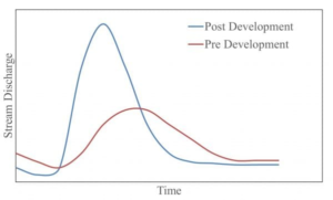
1. Image from the Alabama Cooperative Extension website.
The graph is simple: more hard surfaces mean more stormwater runoff, which correlates to higher stream flows during rain events. The result of this change in hydrology is what leads to “flash floods”.
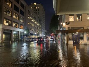
2. Flooding in downtown Roanoke, August 2021.
So, this seems like a big problem, right? How could we possibly fix this?
It is nearly impossible to return to a predevelopment stage. We live in a complex society that requires us to have roadways, commercial and residential buildings, and facilities that are essential for providing community services. There are ways, however, we can manage runoff from developed areas and decrease the discharge of stormwater runoff.
Green infrastructure is a popular way to manage stormwater runoff for multiple reasons. Green infrastructure takes advantage of natural processes to capture, store, and release stormwater runoff. They are effective at reducing the amount of runoff that contributes to the rush of discharge responsible for flash flooding. By collecting water with green infrastructure, we allow for the water to slow down, infiltrate the soil, and slowly release into streams like it would in an undisturbed area. They also capture pollutants, like trash and gas, from impervious surfaces before they have a chance to degrade water quality. This is important for maintaining healthy water quality levels in waterways where people enjoy activities like swimming, floating, and fishing. Green infrastructure helps create a buffer between developed and natural landscapes that are essential for limiting our impact on local ecosystems.
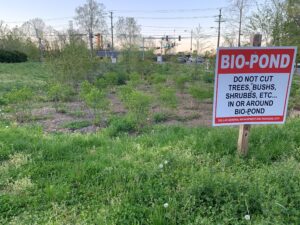
3. Biopond collects stormwater runoff from a parking lot in Roanoke.
We can also encourage our local governments to adopt policies and ordinances that support land conservation. It is important that we take advantage of already developed lands and repurpose them to support the demands of our communities instead of developing natural spaces.
Virginia is working hard to improve flood resiliency. In 2020, Virginia joined the Regional Greenhouse Gas Initiative, or RGGI. RGGI is a cap and invest initiative that serves as a way for Mid-Atlantic states to reduce carbon dioxide emissions from the power sector. Through the effort, states are able to generate funds to support environmental programs.
Proceeds from RGGI auctions help support programs like the Community Flood Preparedness Fund (CFPF). CFPF is designed to support regional and local efforts to reduce the impacts of flooding. Auctions are held quarterly, and the first auction of 2022 generated $72.4 million (!) for Virginia. The most recent round of grant awards was announced in December 2021. The list of funded projects can be found here; see if you can find a project in your community.
The next time it rains, follow the stormwater running off your driveway and funneling down the storm drain. Think about how it impacts the waterway closest to your community and what you can do to help. It could be as simple as installing a rain barrel on a downspout or planting a tree. The efforts we make as individuals and together as a community can improve the health and livability of our region.